The Trail Holding Tremendous Potential: ‘The Great Lake Trail’
The Trekking Agencies Association of Nepal (TAAN) has successfully conducted a on-site exploration visit of the Great Lake Trail under the supervision of the Buddha Himal-Himalchuli Great Lake Circuit Trail Inspection Team. As part of the initiation of Department of Destination Exploration, Study & Development under TAAN, a team lead by TAAN’s Deputy Vice President Dhan Bahadur Gurung, in coordination with the economic support of five municipalities of Gorkha & Lamjung districts (Barkpak Sulikot, Ajirkot, Dudhpokhari, Dordi & Marsyangdi), has completed the first phase of the exploration, planning, and preliminary assessment of various locations within the western ridge of the Manaslu-Himshikhar area (including Manaslu, Harka Chuli, Himal Chuli, Buddha Himal, Thulagi, Punggi, etc.) from Asar 1 to 18, conducting visits to different places under the five municipalities for the identification of new trekking trails.
The journey began with a jeep ride from Kathmandu to Bhachek, and from Bhachek to Baprek, Mamche, Khark, Yuru Khark, Mircha, Narad Pokhari, Dhupi La, Kansathali Marakshyu, Tabi, Dudh Pokhari, Newar Khark, Ghyamro Ra, Tato Pokhari, Ukhand Khark, Meme Pokhari, Meme La, Sarumje Khark, Dahare Gaun, Thulagi Tal, and finally, Nar Danda. The trekking expedition and return journey to Kathmandu via Ghermu took a total of 18 days to complete.
The team was led by Dhan Bahadur Gurung, Second Vice President of TAAN, Mountain Guide and Explorer for Trail Expert (GPS, Trekking Mapping and Trekking Trail Study) Sanjib Gurung, Videographer/Photographer for Documentary (Video/Photo) Lok Chandra Thapa. A team of 15 including Engineer Radha Krishna Gautam for DPR, Mountain Guide Manraj Gurung for Culture and Trail Studies, Kancha Gurung for Trekking Trail Studies, Research and Color Marking, participated in this site visit.
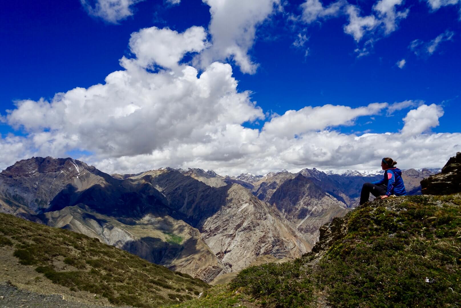
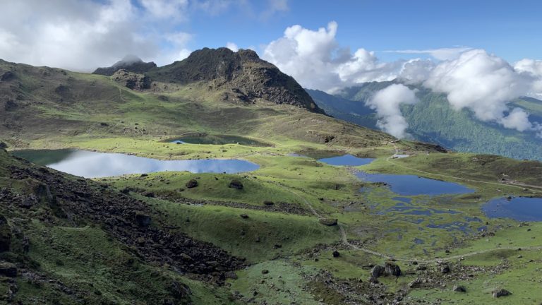
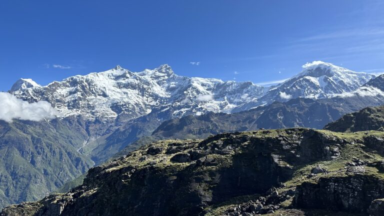
The Great Lake Trail is adorned with magnificent views of large religious lakes, enchanting waterfall scenes, and Himalayan peaks that shimmer like mirrors, such as Himchuli, Buddha Himal, Doctor Harka Chuli, among others. The enchanting views of these geographically diverse landscapes make the Great Lake Trail a gem. Along the trail, one can encounter rare wildlife such as musk deer, red panda, national bird danphe, and many other exotic birds and animals. Various species of rhododendrons, diverse flora, and fauna enrich this trail, offering abundant possibilities for trekking. One can also explore the original culture of the Gurung community, archaeological sites, monasteries, and temples. Overall, the development of a multi-dimensional trail destination that allows for experiencing and witnessing everything appears feasible.
Let’s travel together on The Great Lake Trail:
First day: Our journey started from Kathmandu early in the morning by jeep. I boarded the jeep from Bansathali Chowk at 6 am. There were people named Lok Sar, Man Raj, and Kanchha in the jeep. Our coordinator, the second vice-chairman Dhan Dai, had boarded the jeep from Thanakot. There were five of us in the jeep. After having lunch at Nawise Thakali Bhanse Ghar, we faced traffic jam at Malekhu. We traveled 12 km to Gorkha with a local resident up-to La Gari Bacchek. Sundar Bhanjyang was situated at an altitude of 1700 meters. In the Bhawan of Ajirkot Rural Municipality, five rural municipality chairpersons welcomed our team and wished us luck for the journey. After dinner, four of us stayed at the house of Gogan Pani Dhan Dai.
Second day: The next day, we woke up early and went to Bhacchek Hotel. After breakfast, we visited Bhacchek Hospital and then went to meet with the Village Municipality Chairpersons and journeyed with them till Siran Danda. Our trekking journey starts from Siran Danda and after walking through the jungle towards the east for some time, we reached the Mathar village. If traveled a little futher we would be able to reach Ghya Chowk. The path is relatively easy from Siran Danda to Ghya Chowk, with no steep ups and downs. After walking for about half an hour from Ghya Chowk, we quickly reached the Tutir village.
The local mothers’ group warmly welcomed our group with flower garlands. They had also arranged lunch for our group. After lunch, we had to rest for a while due to heavy rain. After about half an hour of traveling downhill from the village we reached Chun stream and then we would reach Daraudi suspension bridge. After crossing the suspension bridge, it was a steep climb towards Baprak. After about 2 hours we reached Baprak via Aal Gaon, Aaldang. There are good hotels and homestays here. That day I stayed in the hotel. We were also introduced to all the helpers who were going with us. Krishna sir also came and stayed in Baprak.
Today’s journey was made enjoyable by villages, waterfalls, rivers, mountains and geographical scenery. Some places need to repair the road and build the square. On the first day, everyone felt that the walk was a bit too much
Third day: After breakfast, we visited Baprak Earthquake Park, Gumba, Maulakot, and Buddha Park. Before starting the journey, the host group at Baprak Homestay welcomed us with flower garlands and tea, and bid us farewell for the journey ahead. From Baprak, the road gradually ascends traveling via Thoyor, Sunin Pani continuing to Mamche. There was a hotel in Mamche. Our lunch for the day was also at this hotel. After the meal, as we kept walking we reached Chonga Khark by going up and down the hill. As the night was approaching, it was decided to camp out the night there.
Due to the weather, we couldn’t see the scenery as we had hoped today, but when the weather clears up, we’ll be able to see the Himalayas and the geographical scenery along the entire route. This path along was filled with rhododendron blossoms. During the months of Chaitra and Baisakh, when rhododendrons are in full bloom, this place becomes like heaven.
Fourth day: Today’s journey started at 8 o’clock in the morning. From Tangim, Lamra, Yuru Khark, the path follows along the ridge, tracking the sheep up to Bedi Khark. From Bedi Khark to Russe Kharkthe path was lightly slopping downwards. After eating Chiura Biscuits in Russe Khark, there was unpaved road to Mircha. By the time we reached Mircha, it was already 6 o’clock. Today’s journey was also a long one. Due to bad weather, sightseeing couldn’t be observed. The road has been repaired, which is good, but there is a need for a bridge in the Mircha stream. There is a rest house named Mircha Rest House in Mircha. We stayed in the same rest house. There were also locals who search for wild garlic for their livelihood in the rest house.
Fifth day: After lunch as always, we started focusing on studying the path ahead. After climbing 500 meters, we reached Narad Pokhari. As we walked towards the Mamche Khark, the trail became steeper. It took us about 3 hours to reach Narad Pokhari. Dharmik Astha Pokhari is situated at an altitude of 4109 meters. Especially the people of Gorkha district visit this lake on Janai Purnima day for pilgrimage. There are steep cliffs near the lake, where we cooked our lunch and ate. Just above Pokhari, the trail became narrow, and we had to cross a small pass. Due to the snow on the trail, the journey became a bit challenging. As we moved a little further downhill we encountered an alpine pasture, then we started searching for the trail after crossing Chilam river. After some time of searching, we got lost and lost the trail.
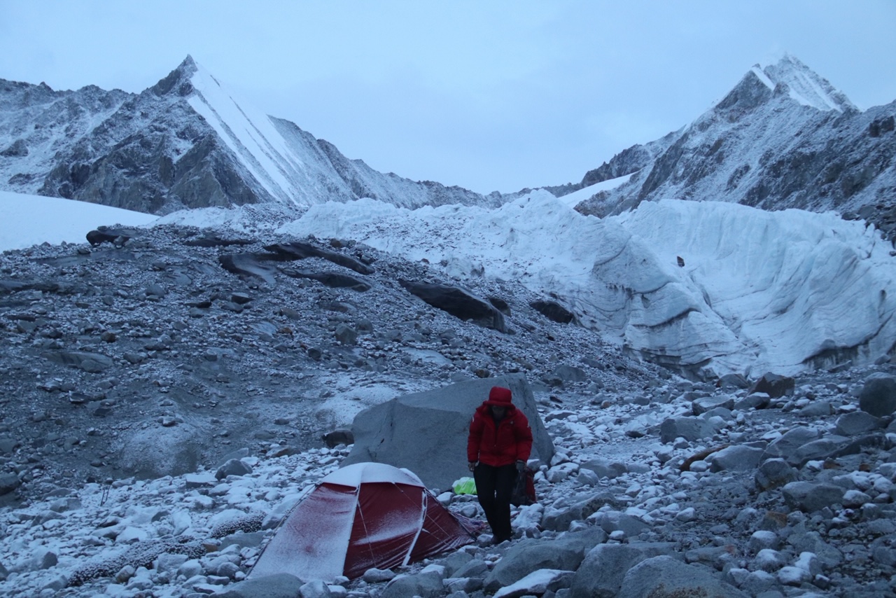
Everywhere we went there were only cliffs. We fell in dilemma, it was getting late as well, due to the cloudy weather everyone were panicked. Finally, after going down a little from the cliff, we found the trail used by herdsmen. After following the trail downwards for some time, we reached a steep slope. . Following the trail, after some uphill climb, we came to the snowy road of Khaire pass. A little further down through the snowy road we reached Khaire River.. Since it was getting dark and there was a place to camp, we decided to camp there for the day. For an easy trek, the entire trail needs maintenance, and necessity of a bridge over the Chilam river. But for adventurous travelers, this trail can be hidden gem.
Today’s journey was very difficult due to the bad weather condition, snowy road and having lost our way along the trail. We all were completely soaked when we reached our accommodation site.
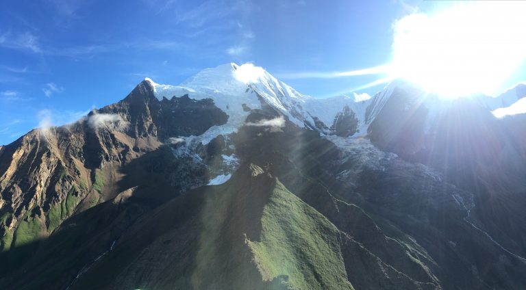
Sixth day: In the morning, the weather was clear. Waking up early we went sightseeing around the Khaire pass. From here, looking towards Baudha Himal was as if seeing yourself in the mirror. Below, the lush green forest, the picturesque scenery, is enchanting. We also saw that from the base of the Baudha Himal, it is possible to reach a pass at 5038 meters, from where it seems easy to go to Meme Pokhari via a small trail. There is also a path that leads directly from Mamche to Chilam Khola.
There are two paths from here, one goes down for a roundabout path and the other is a shorter path through Dhupi La pass. We chose the path through the Dhupi La pass. From Khairi Khola to Dhupi La, it’s about 500 meters in altitude and it’s a steep climb. There was a lot of snow at the pass. It took a long time to make the path in the snow. It would have been nice to have seen the scenery from the 4671-meter-high Dhupi La pass, but it wasn’t our luck to see the view. At the beginning, there was a rocky road like a landslide, and then there was a four-sided cliff. From the pass to Tal Khark, about 500 meters below, it was a steep descent except for a few places.
After crossing the Pau River from Tal Khark, we continuously studied the road. Passing through Bugle Deurali we reached Kansthali Mercasu. Since there are 3/4 of the same Deurali, it is called Bugle Deurali, while Kansthali Mercasu is a historical place. At one time, all the sheep and sisters of the barn were lost in this place. There was a pond and holes here and there. According to Kimb Danti, there is a folk-story that the sheep and sisters had vanished in the same pit. Kansathali is a beautiful place, from where one can observe the geographical scenery of Gorkha district and glimpse the Himalayas. After going to some lower terraces from Kansathali, we set up our camp for today.
Today’s camp was delightful. After the journey, we were able to have our first glimpse of the village. In the evening, we saw twinkling lights in the distance.
Seventh day: Since our journey is still long, it seemed like we might not have enough food. The coordinator has decided to send two helpers to the village to buy groceries for food arrangements. The village was nearby from there and it’s also close enough to visit another day. That’s why two companions from our team went to the village early morning and returned until the afternoon tomorrow to the next camp.
Today’s journey was short. After breakfast in the morning, we set out for our next destination, Knarku Khark. The trail was relatively easy until Siran Khola, then a slightly uphill path for a short while to Dadako. From Dadako, after descending again, Knarku Khark came into view. The meadows were adorned with beautiful wild flowers. Today’s journey was short but enjoyable. There were herds of sheep, goats, and yaks in Knarku Khark. After dinner, we camped right there. The quick stay also meant, to wait for our companions who had gone to the village for food arrangement.
Eight day: Yesterday, the two companions couldn’t arrive but then we started journeying towards the Dudh Pokhari in the late morning as we planned to meet them at the another camp. After climbing up Deurali via Fedhi, almost around 3:30 hours of steady ascent, we reached Dudh Pokhari. We also met a local guide arranged for the Mem Pokhari. Dharmikasthan Tal lies at an altitude of 4535 meters. The small but beautiful Pokhari is especially visited by pilgrims from Gorkha and Lamjung districts on the day of Janai Purnima.
Following the local guide, taking a horizontal turn and lastly descending downhill we reached Gairi Khark. During the rainy season, the sheep grazed in the field. Targeting pilgrims a camping site was made there and here was where we set our camp for the night. Using this trick, a new plan came to our mind. It was suggested to develop this area in the sequence of trail development, bringing together the village and tourism. We thought of making the cowshed a well-organized house so that shepherds can stay during the dry season and tourists can come and stay during the tourist season. In this way the shepherds did not have to build a shed and the tourists did not have to bother carrying and pitching their tents, thus advancing both simultaneously.
Ninth day: Our two companions had stayed at Knarku Khark. As they had travelled to the Khark taking a shortcut without visiting the lake, we met them in along the way through the Khark. The trail was very easy and smooth (horizontal) to walk through. After crossing Nabewar Dada, the local guide also lost his way after walking for a few hours up and down in Guras Dhari. But then after searching for a while we again found a shepherds’ trail. It was getting dark and we were searching for a place to camp at. We arrived at a small Khark like place, so we decided to camp there. Due to the bad weather, our journey did not go as planned. We got lost at many trails due to the fog.
Tenth day: The next morning when we woke up, the weather was very clear. Therefore, we quickly began our journey. After trekking uphill for a while, we encountered Buddha Himal and the Himalayan Range sparkling like a mirror. Beautiful views of cliffs, dense forests, and settlements were also visible below. Luckily on the way, we were able to spot a mountain monal and a musk deer. After enjoying some picturesque views, our journey continued uninterrupted. Nearby, Gyamlo Lake (known as Dudh Pokhari in Gurung language) could be seen. After crossing a small cliff and cutting through another jungle, we reached a sweet waterfall called Pokhari.
Beyond Pokhari, the path became rugged, with the road barely visible under the scorching sun, surrounded by rhododendron and bamboo forests. A hunter had set a trap in Gurash Ghari. A musk deer was found dead in a trap without its navel. After a continuous descent, we had reached the river. Lunch was done in the area near the river. After lunch, we had taken to the road seen earlier. While going uphill, we had seen 3 hunters but didn’t meet with them. Going a little forward we came across another trap set by the hunters where a dead mountail monal was lying. In this area, there have been many incidents of theft and robbery. Concerned authorities have seen the need for prevention.
After a steep ascent, we reached a Khark but due to the rain our visibility was reduced and we couldn’t see anything. Continuous horizontal climbing led us to a cliff where we again lost our way. Despite searching in the rain and windy weather we couldn’t find the way. We saw the path for pilgrims below the ridge. To reach the path we descended along a narrow stream. After nearly half an hour of descent, we found the main trail. After about 2 hours of continuous climbing, we reached Ukhanda Khark. By the time we reached there, it was already night time. All of us were tired because of the rugged pathless forest and steep ups and downs. There was a rest house there. We stayed the night at the rest house.
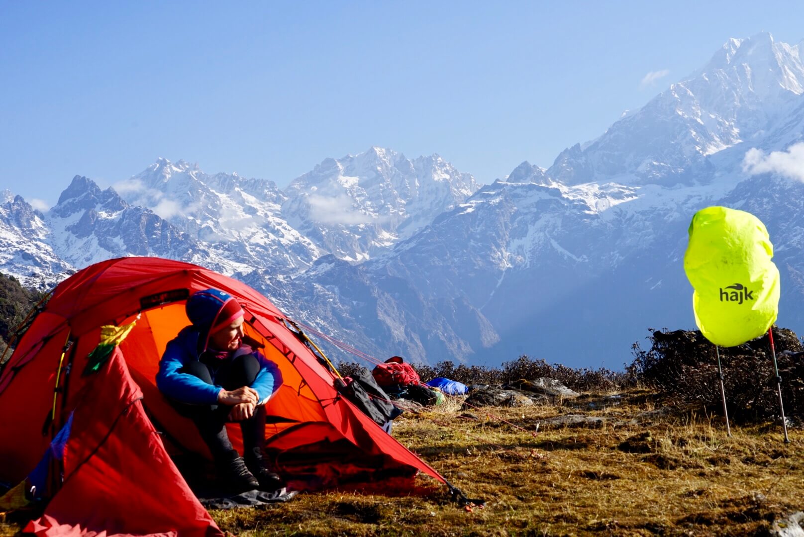
Eleventh day: Today, our journey led us towards Meme Pokhari. We started the journey by having lunch instead of breakfast. After climbing approximately 1000 meters via Baghe Pokhari, we reached Meme Pokhari. Meme Pokhari, located at an altitude of 4436 meters, was beautiful and quite large. It was 1 o’clock in the afternoon. Including Meme Pokhari, there are six other lakes like Tarwali Tal, Batara Tal, Pargyo Ra Tal, and Dudh Pokhari. Meme Tal, like Narad and Dudh Pokhari, hosts a fair during Janai Purnima. Many pilgrims come to visit here as well.
As it took too much time to visit the lakes, we got ready to stay there. This lake is located on the foothills of the Himalayan range. This place was the most exciting part on the journey. Meme Pokhari is the best destination for a short trip, observing lakes, seeing the Himalayas, and enjoying the scenic beauty. Meme Pokhari is an excellent destination for a short trip, observing lakes, seeing the Himalayas, and enjoying the scenic beauty.
Mangal ji and I went to Meme Pass to see if we could go to Thulagi Lake from the top without needing to go down and waited for the weather to clear for about an hour. But the weather got worse, we came back and it was decided that we would take the circuitous route to descend.
Twelfth day: As the weather gradually cleared up, I quickly got up in the morning to take photos of the scenery. Near Meme Pass, I saw 4 or 5 Himalayan goat. To take photos and look at the other path, I went with a brother from our team to see how it was. Most of the mountain goats had ran away. But from near Meme Pass, I also saw Thulagi Lake and a half-maintained path to walk through.
Discussing with the team after returning to the camp, everyone agreed to take the path. The local guide returned from Meme Pokhari and our team started the journey to Thulagi by passing a short straight road from Meme. After a while, we reached Sani Pokhari and Kharak. However, the weather also deteriorated. We met the path after a while of walking. Following the path, we came across the hill seen from Meme Pass. Since there was a road, it was decided not to wait for the weather and to continue the journey. As we walked downhill, we soon reached Surumje Khark. From the Khark, there were two roads, one going downwards and the other one leading towards Thulagi Lake.
We decided to take the road to towards Thulagi. After reaching Cuba Khark, the road came to a dead end. We searched for the trails but couldn’t find any. Then followed a trail looking like a road, but we reached at a cliff instead. There was nowhere to go. We were moving down towards the river, when the weather slightly cleared and we saw the cliff at the other side. Seeing no possible trial our team decided to return back to Surumje and take the road leading downhills instead.
Approximately 5 hours later, we reached the same stream. It was already 5 o’clock, but hearing that there was a hydro facility further ahead, we hastened. After some time, we reached a narrow trail and reached Ramailo Danda. It was getting darker and darker. The path became steeper and steeper. Night fell, and since we couldn’t go ahead, so we decided to look for a place to stay. We encountered a water buffalo but no water was found. It was decided that we would stay without food and only ate biscuits.
Thirteenth day: After waking up in the morning, we followed the path downhill. After a short descent, we arrived at Bhaisi Khark. After getting the information from a local of the village we started our journey towards Dahare village. After going down the forest for a while, we found a road dug by hydro. The road eventually led us to Hidi hydro office. We reached the office and had our meal cooked there. After the meal, we descended again, passing through a river, and finally reached Dahare village. We stayed in a small shop near the army camp. A local employee of the Hidi Hydro Office helped us by searching for a local of the village who showed us the way to Thulagi Pokhari.
Fourteenth day: We departed for Thulagi lake from Dahara. In the beginning, we reached Play Khark through a steep uphill and a horizontal (slightly uphill) path in the forest. A new hydro office is being constructed at the plain, and two bulldozers have dug a road approximately one kilometer long. Due to the rainy weather, we decided to stay there for the day. We had to cross many small rivers and 2 big rivers to reach Play Khark. While observing the waterfalls, Pirumja Khark, Sodo Khark, Pongyu Khark one reaches Play Khark.
Fifteenth day: The rain didn’t stop. It continued to rain throughout the whole night. The construction work started in-between while raining. At the end of the road, you have to cross Play Khola (Thulagi Khola). The source of this river is Thulagi Pond and it is also called Thulagi River. The old walking path to cross the river was from under the road. We were just going to see if we could cross the big river through the medium of the wooden logs and ropes but then a rock fell over one of our team member Dhan dai. Luckily the rock was small and had fell on his backpack on his shoulders.
As going through that road was very risky, we decided to take another pathway. After knowing that there’s a path through which shepherds would go around the hill in an hour’s difference, then we decided to take that path. In that place, there’s a wooden fence built; it looked old. We checked the rope tied around the wood for support, then using the rope as a support everyone crossed the river. The road till It is horizontal up to Parkiu river and steeply uphill from there to Lovi Khark. Eating snacks at Lovi Khark we headed towards Thulagi Khark. There was a rest house in Thulagi and we stayed the night there. Lovi Khark and Thulagi Khark have various species of flowers blooming.
Sixteenth day: In the morning, we set out for a hike to Thulagi Lake. It took us two hours to reach Thulagi Lake and one hour to return. After returning, we had our meal. We discussed about reaching Sanjapu village by evening. According to that, we started our journey. After walking for about an hour, the trail gradually became steep, and then slight climbing uphill we reached Moge Khark. From then on travelling from Mens Khark via Didi-Bhahini Chautaro going uphill and downhill, finally we reached Nar Danda. Going downhill we separated from the local guide as he travelled towards his village and our team towards Sanjapu.
From Nar Dada to Sanjapu village, it’s quite a descent. We reached Sanjapu around 8:30 in the evening. There are various shops along the way. It seems that the municipality chairman has arranged for accommodations such as the Youth Club and Homestay in Sanjapu. There was a majority of Gurung community in Sanjapu. The hosts welcomed us with homemade liquor, rice, yogurt, and buttermilk. Homestay was available for sleeping. After eating a lot and feeling tired from the journey, we immediately went to sleep.
Seventeenth day: In the morning, the villagers welcomed us with flower garlands. From there, we ascended towards Ghairung village. The wome community of Ghairung village had also organized another welcoming program with flower garlands for our team. After program, we enjoyed the meal prepared by the women’s council in the community house. After the meal, we bid farewell and headed towards Syange waterfall where a jeep was waiting for us. From Syange, we traveled by jeep until we reached Besisahar.
We reserved a Hiace from Besi Sahar and, with the help of the supporter, reached Kathmandu after leaving 12 kilograms in Gorkha. We arrived home in Kathmandu at 1 a.m.
The Great Lake Trek: Possibility of Manaslu
Nepal being a country which is rich in natural resources and cultural diversity, has very immense potential for tourism. Among the world’s 14 highest peaks, 8 are located in our country. Beautiful geographical landscapes, waterfalls, lakes, and hills, not forgetting about the valleys. Despite the abundance of tourism potential, only 2/4 regions are well-known tourist destinations. Recognizing the importance of this topic, relevant organizations, local governments, and the national government are actively seeking new destinations for tourism. That is why, the feasibility study of the Great Lake (Manaslu) trail has been completed at the initiative of TAAN and the village council or municipalities.
The Great Lake Trail offers abundant opportunities for adventurous trekking in the Manaslu region. It’s an alternative trek to the traditional Manaslu and Annapurna trekking trails, which are increasingly affected by motor vehicles. The circuit trek is feasible, allowing trekkers to see glaciers up close, observe stunning Himalayan views, encounter incredible geographical landscapes, and witness numerous lakes along the way. With fewer risks such as avalanches and rockfalls, this trail has great potential.
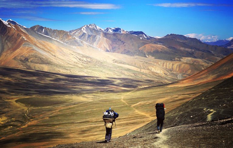
It can be completed in both short and long durations according to the tourist’s schedule. One can reach and return from places like Machha Khola, Laprak, Bapraak, Bhachek, Base Camp, Bulbule, and more. Although there may be some connectivity issues in certain areas, in case of emergencies, settlements like Narad Pokhari, Dudh Pokhari, and Meme Pokhari have become pilgrimage sites and are accessible for travelers even now.
Short trips are still very much possible for domestic tourism, such as Narad Pokhari Trek, Nage Pokhari Trek, Nage Dudh Pokhari Trek, Meme Pokhari Trek, Thulagi Pokhari Trek, which can be done in just 4/5 days. Localities also suggest using these routes for trekking to Himalchuli and Budhha Himal.
From wherever one can travel, the impact of motor vehicles cannot be seen or felt. In the Great Lake, Manaslu Trek, one can see a lot of things such as the Himalayas, lakeshores, waterfalls, various types of wildlife/flora/fauna, Gurung/Tamang culture, monasteries, temples, stupas, etc. This pilgrimage can quickly create the possibility of overcrowding for tourists due to the creation of basic infrastructure. Those who are interested in adventure tourism can start camping for treks as well.
Possible Trekking Itinerary:
Day 01: Kathmandu to Babare Bus Journey
Day 02: Babare to Lamra Kharak Trekking
Day 03: Lamra Kharak to Mircha Kharak Trekking
Day 04: Mircha Kharak to Khaire Khola Trekking
Day 05: Khaire Khola to Tabin Dada Trekking
Day 06: Tabin Dada to Gairi Kharak Trekking
Day 07: Gairi Kharak to Ngwamlo Ra Trekking
Day 08: Ngwamlo Ra to Ukhanda Kharak Trekking
Day 09: Ukhanda Kharak to Meme Pokhari Trekking
Day 10: Meme Pokhari to Jaljale Kharak Trekking
Day 11: Jaljale Kharak to Thulagi Kharak Trekking
Day 12: Thulagi Kharak to Nar Dada Trekking
Day 13: Nar Dada to Ghermu Trekking
Day 14: Ghermu to Kathmandu Bus Journey