Kanjerawa Himal Explore & Study Expedition 2016
Possibility of Tourism in Dolpa district
Dolpa district, inspire of being rich of its own religions and traditions also natural beauties, it hasn’t been yet developed in the field of tourism. We have found two main reasons why it isn’t developed yet. Among those two, first one is lack of transportation facility and second is lack of advertisement. Commencement of transportation facilities and development of communication and information should be done. Because of which there will be increase in internal as well as external tourist in near coming future. This district is famous for its religion, natural sources, and country’s most expensive medicinal herbs. That is why Dolpa is considered as one of the district that carries long-term possibility of tourism. In near future, there should be not only mountainous tourist but also include religious tourism, rafting, kayaking, canoeing, and training for mount climbing.
Key Note:
Mountain Name:Kanjerawa 6612m
Located:Dolpa District, mid western Region Nepal/inside Phoksundo National Park, Near SheyPhoksundowhich is Nepal’s deepest Lake.
Trip Duration: 18 nights/19 days
Climbing Duration: 7 Days
Logistic: Camping/Basic guest house
Trip Grade:
Introduction
Having its own distinctiveness KanjerawaHimal is situated in Dolpa district inside Sheyphoksundo national park at an elevation of 6612m having Latitude 28°14’00” and Longitude 82°52’35”. In Dolpa, this Himal is also known by its local name known as GangchhenralwaHimal. The meaning of this name is described as: Gangchhen means Big Mountain and Ralwa means Horse’s mane. It is called so because when you see the mountain, you will see it as the neck of the horse and some straight lines on the mountain that seems to be like the horse’s mane. KanjerawaHimal stands beautifully right on the Phoksundo Lake and is 2nd tallest peak in Dolpa but the lack of right information about this peak have put the climbers in deep confusion and also prevented the climbers from climbing this peak. But as per the local source, Japanese were the first ever to make an effort to get to the summit of this Himal although many foreign and nationals have then made an effort later however no evidence of any climbers making to the top have been recorded till date.

With an immense moral and financial support from Nepal Mountaineering Association (NMA), District Development Committee and others, we the team of climbing guides and the local trekking guides formed a team called “KANJERAWA HIMAL EXPLORE AND STUDY EXPEDITION 2016”. A little fact on this team would be informative. This is not any organization or an institution. The team have individually and voluntarily come together to work on this project. KanjewaraHimal being one of the unclimbed Himal because there was no location and no climbing routes had been discovered, the team then decided to initiate the study and explore about the KanjerawaHimal and we started from Dolpa District on July 2016. After a month of complex study, we succeeded in discovering the base camp 4506m and safe climbing route. Our team discovered that this Himal could be climbed safely and easily from the south ridge as compared to other sections. Despite the bad weather, we successfully climbed the second summit of Kanjerawa 6426m and according to our study, it is actually not difficult to get to the main summit 6612m from the second summit. We also ended up discovering that to climb the KanjerawaHimal, we need to set Camp1 5322m, Camp 2 6000m.
Recommended Climbing Gear:
Climbing Route:
Kanjerawa Expedition Day Itinerary:
Day 01: Kathmandu-Nepalgunj
Flight Duration: 55Minuets
Accommodation: Hotel
We take a flight to Nepalgunj from Kathmandu Aiport. The flight is going to be a regular flight which takes 55 minutes to reach at Nepalgunj. Nepalgunj is the Central point to fly to western region of Nepalwhich is in Banke District close to southern border in India. There are many airline options available like: Budha Air, Yeti Air, Nepal Airline and more to fly to Nepalgunj. FromNepalgunj you can also fly to Dolpa and Jumla region. There are good hotel facilities available here in Nepalgunj and other facilities like shopping center and malls as well. Since Nepalgunj is situated at 170m from sea level, it is quite a hot place as compare to other places in Nepal.

Day 02: Nepalgunj-Juphal-Dunai
Flight duration:
Distance: 13.50km
Walking Hour: 4hr
Lunch at: Juphal
Drive Duration: 1hr
Every morning flight to Dolpa from Nepalgunj is available but not after 12 noon because the weather can be really windy and at times foggy too. There is only one airport available if you want to fly to Juphal from Nepalgunj and the airport is at altitude of 2475m from Sea level. Some airlines like: Tara, Goma, Kastamandapetc serve to fly Juphal from Nepalgunj. Since flights are depended on weather, sometime they don’t even have flight for a week but situation may not always be the same. Juphal is a delightful place offering a pleasant view of Mount Kagmara along with beautiful surroundings. Kanjerawa Expedition trek starts from Juphal.
A trekking to Dunai from Juphal can be made or can also opt for a jeep to reach there. The road is quite bumpy but it takes only 1 hour to Dunai, but if you choose to walk, it takes around 4 hours of walking. In the beginning the trail goes to down south east direction to Rupagaad (River) close to ThuloBheri. After Rupagaad the path goes via Suligad flowing ThuloBheri valley till Dunai. Since there is no other route option, almost 80% of jeep trail should be followed but with little disturbance by jeep sometime. Dunai is a district headquarters of Dolpo and everything can be arranged easily from there. At Dunai there are facilities like Hotel, Hospital, email Internet or manymore.
Day 03: Rest and Trip Settlement
Today we arrange for donkeys, kitchen staff,manage climbing gears and also shopfor some foods.
Day 04: Dunai-Shyanta 2585m
Distance: 14.81km
Walking Hour:5hrs
Lunch at:Kagani
The trail overall is not sodifficult. We will start our Trek by crossing the ThuloBheri River and flow north bank Bheri river till Suligadand take the same route to return backwhich we used before. After Suligad, we will then to head north bank of Suligad River. From Dunai, the 1st stop is SheyPhoksundo National Park Checking post, Sulighad. The trail ascends gradually till Kageni whichis the small and a charming village with tea houses and some home stays. So at Kageni, we will stop for lunch and after lunch will again cross Suligad River and arrive at Shyanta. At Shyantathere is a small tea house and also a camping place close to the river.Overall, as we walk, we can get pleasure from some the stunning scenery and also get familiar with some different plants around.
Day 05: Shyanta-Rechi 3009m
Distance: 12.87km
Walking Hour:5hrs
Lunch at:Phaparbari
Today we will have quite an easy day since we just have to climb 500m. The trail goes to SuligadRiver and at times, we will cross river, rocky george, rock cut section and humid mixed forest. After hiking for45 minutes, we will reach to Chhekpavillage where we can find tea houses and camping places. (You also have an option of coming to Chhekpa straight from Dunaiwithout stopping at Shyantatoo). After hiking for 3 hourswe then get in to Phaparbari. It isplace with no houses but some tent tea shops are available and also quiet a good stop for lunch. After lunch, we will continue to hike the same way up crossing newly opened short trekking trail, and cross river to reach Rechi village. This beautiful village is located near Suligad River.

Day 06: Rechi-Yak Kharka
Distance: 11km
Walking Hour:5hrs
Lunch at:Pugmo
We will have a bit longer but an easy route to hike.As we hike, we will follow Suligad River until Sunduwawhich is an intersection. And after we pass through Sunduwa we take our left side north-westtrail in the direction ofPugmoKhola (River). At Sunduwa, thereis Nepal army and National Park Post and after which comes Pugmo village – a last village of Kanjera Expedition. This is a very nice place to stop for lunch and there is also a monastery called Bon Monastery and a guest house. After Lunch, we will continue to follow the edge of ChugadRiver till Yak Kharka.
Day 07: Rest and Acclimatizing
Day 08: Yak Kharka-Kanjerawa Base Camp 4506m
Distance:3.5km
Walking Hour:5hrs
Lunch at: Lunch Camp
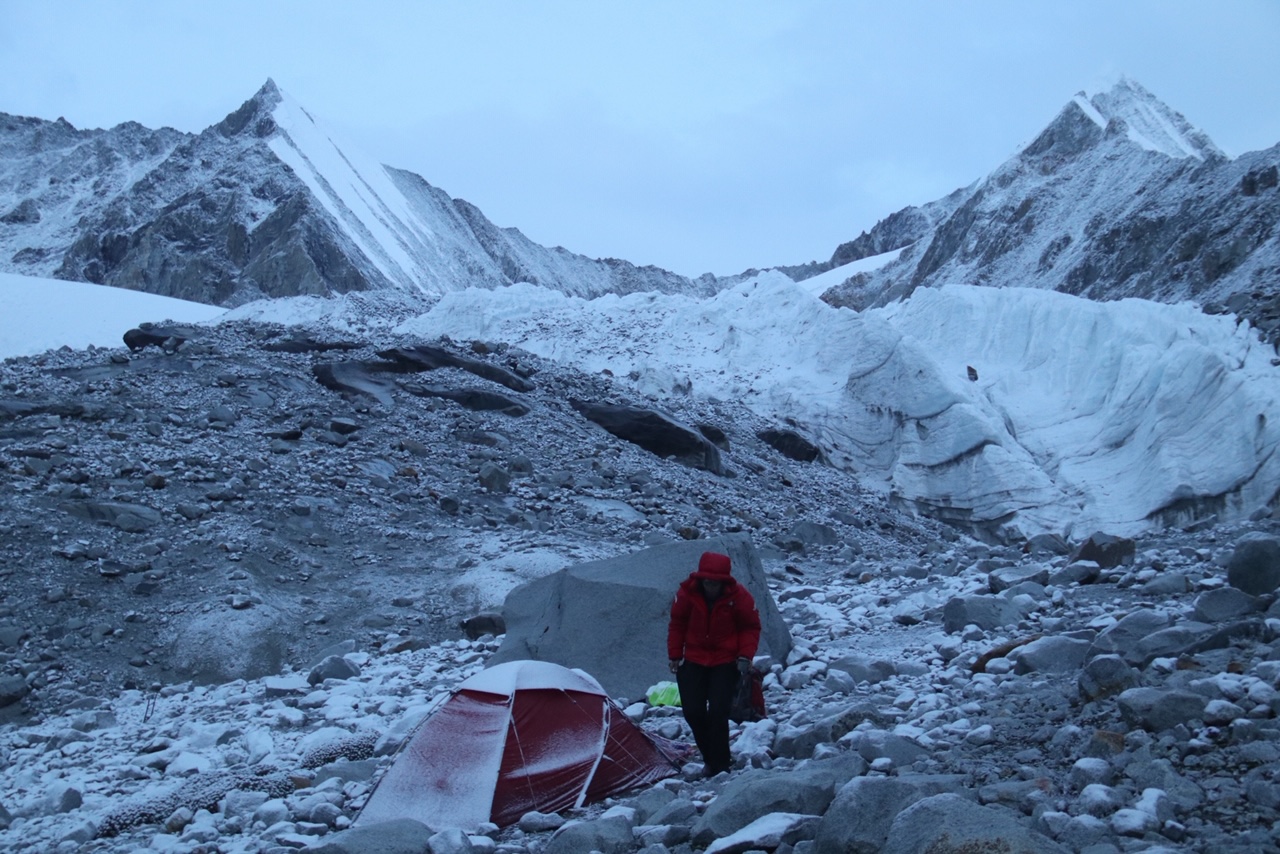
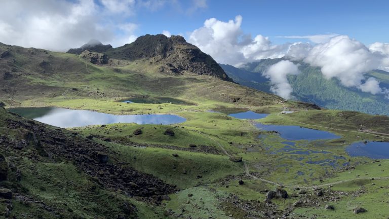
It will takeus 3 hours steep climb till halfway from Yak Kharka and reach to a ridge point through north direction and then we will cross this ridge point and take to east. As we hike, we will come across many rough cliffs. Hiking for another one and half hours will lead us to our destination Kanjerawa Base Camp.While hiking, we can take pleasure in some magnificent mountain ranges like: Kagmara, Lhasharma, Kanjerawa including beautiful PungmoValley which is simply beautiful. Base Camp is the best and safe place to enjoy camping. The place is quite spacious and also has natural spring water. A little disadvantage is that the trailto base camp is bit rough.

Day 09: Rest and Acclimatizing
We can have full rest today but if interested, just a little hike to some hills nearby or glacier or just enjoy your surroundings. After lunch, the guide can instruct on climbing techniques in the Himalayas.
Day 10: Camp 1, 5322m
There are two ways to get to Camp 1. One through the ridge which is on the left side and the other one is by the right side through the glacier. The left side of the way (around 500m) is bit difficult and risky due to sharp ridge with loose rocks around. It is also difficult in this place to make anchor point or running belay. The right side of the way is bit risky due to the avalanches here. This Came 1 is very big and wide. This place is also safe.
Day 11: Camp 2 6000m
After climbing for fifteen minutes, crampon points will begin and from here we will continue climbing to Kanjerawa south ridge until we reach Camp 2.
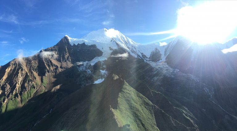
Day 12: Summit Kanjerawa 6612m and Back to Base Camp
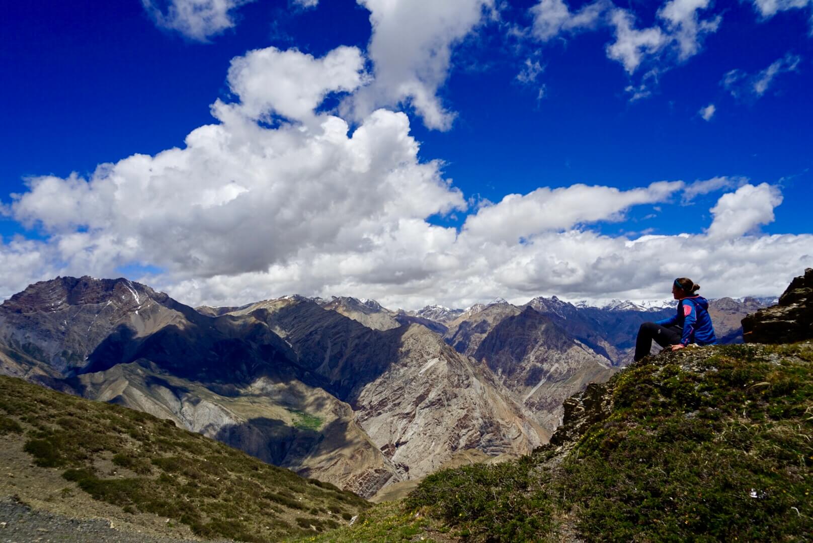
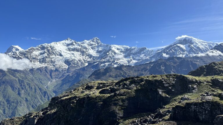
We will have to walk in a vertical climb for a while and after that begins quite a smooth trail until we reach the summit. The summit of Kanjerawa Mountain awaits us to welcome us with its magnificent views around. You can have views of Phoksundo Lake and some breath taking views of beautiful surrounding landscape. Some beautiful mountains include: Mt. Dhaulagiri (8167m), Putha, Kanjiropa Range and also some other mountains. There cannot be any overwhelming moment in life other then witnessing the landscape and the mountains.
Day 13-14: Extra Days
These extra days can be set aside in case of a bad weather or if any of the climbers need any extra time to acclimatize. Else we can enjoy the beautiful surroundings and also capture some through photograpy.
Day 15: Kanjerawa Base Camp –Pugmo 3268m
As we come down, the path can be bit rough walking through the rocky cliffs. The hike will take us about an hour and half hour until we reach a ridge point. We will then have to hike for two hours down in a straight line and arrive at Yak Kharka. We will have to hike from here for one and half hours. The trail is not as difficult since we will have to descend all the way until we reach Pugmo.Pugmo is a small village inhabited by the ethnic group called Sherpa. The Sherpas here indulge mainly in agriculture. They mostly grow wheat, potato and buckwheat. These people follow the religion call Bon which is theoldest religion in Nepal. In this religion, they do not pray or follow any particular God but they believe in paying tribute to Mother Nature and the deceased souls.
Day 16: Pugmo-Rigmo 3645m (Phoksundu Lake)
Distance: 12.59km
Walking Hour:5hrs
Lunch at:Chunuwar (Tapriza School)
Rigmo is a small village which is similar to Pugmo village in many ways. They share the same culture and the religion. There is also a famous Bon monastery here located a few kilometers away from the village. Both the monastery and the village are located at the base of Phoksundo Lake.
We will begin to hike from Pugmo to reach to Sunduwawhich will take around one and half hour and here we hike following the PugmoKhola (River) valley. Then following the trail that changes to the north east side through PhoksundoKhola, we will hike to come across many breath taking landscapes, pleasant villages, mountain views and striking and milky-looking waterfall that come through Phoksundo River. After we arrive at Rigmo, we can take pleasure in some of the outstanding views around us.

Day 17:Rigmo-Shyanta 2585m
Distance: 20.5km
Walking Hour: 6hrs
Lunch at:Rechi
We will begin our journey and hike towards the old Bon Monastry which is just few kilometers from here. After our visit to the monastery, it is all the way downwardsfollowing PhoksundoKhola and Suligad (River) valley and hike through some traditional villages from Rigmo to Shyanta.
Day 18: Shyanta-Juphal
Distance:15.5km
Walking Hour: 6hr
Lunch at:
There will be a continuous hike as we follow the trail till Suligad River. We will change our trail to west and then continue hiking taking a steep path to reach to Juphal.
Day 19: Juphal-Kathmandu
Juphal-Nepalgun flight Duration: we will have our early morning flight awaiting us. The flight will be of 40 minutes. Then the same day will be followed by another flight i.e. from Nepalgunj-Kathmandu with flight duration of 55 minutes.
By: Sanjib Gurung